-
觀音山牛港稜 Mount Guanyin, Niougangling
 A short but difficult extension to the Guanyinshan offroad trail. Les inconvénients du Fengshui.
繼續騎觀音山越野道路,這條又短又難。


Sur les flancs du Mont Guanyin il y a énormément de Fengshui mais pas une âme qui vive. Et pourtant il y a bien là une large population silencieuse regardant la mer et écoutant le vent siffler entre les collines... Il ne s'agit pas des randonneurs, peu nombreux et plutôt bruyants, mais du peuple des âmes défuntes - car la montagne est largement recouverte de sépultures... Ouvertes sur le ciel, la mer et la nature, ces cités funèbres contrastent singulièrement avec les cités des vivants : c'est peut-être bien là le paradis sur terre, se dit-on en les découvrant la première fois !
Relisons Henri Michaux qui voyagea en Chine continentale dans les 1930 et exagéra à peine : "D'ailleurs le tiers de la Chine est un cimetière. Mais quel cimetière !
La campagne chinoise, quand je la vis pour la première fois, m'a été droit au coeur. Des tombes, des montagnes entières (ou plutôt le flanc de l'une, le côté Est d'une autre), couverte de tombes, mais pas de tombes dures et droites, non, d'hémicycles de pierre..., qui invitent. Il n'y a pas d'erreur, elles invitent."
Tout est dit en ces quelques lignes; je dois toutefois reconnaitre qu'à l'instar des autres occidentaux je suis suis peu sensible à ce genre d'invitation... d'où une certaine aversion au Fengshui par ailleurs !(photo censurée)C'est ainsi que je j'ai consacré l'essentiel de mes promenades dans ce massif à la recherche d'itinéraires évitant les cimetières. Je dois dire que le résultat est maigre. Entre autres raisons car les cultivateurs de bambou barricadent leurs terres avec des grilles et des palissades en tôle, de crainte de voir l'exquise géomancie attirer davantage de sépultures... Et là il faut reconnaitre que le Fengshui en prend un bon coup !


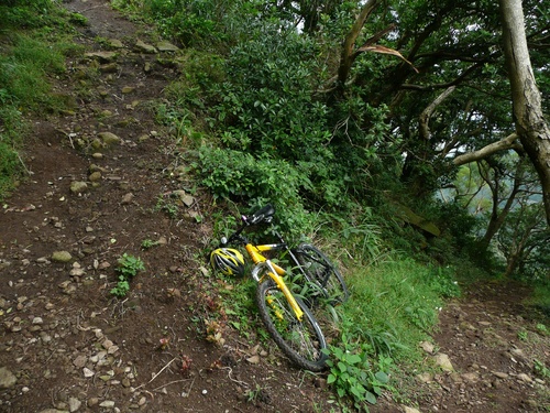
The first time I went to the Niougangling (牛港稜) to investigate about the trails on the southern slopes, I first inquired at the excellent Visitor Center. The ranger on duty that day gave me the usual answer "這邊沒有路" (there is no road on this side). I wish I had listened twice, since after several gardening sessions to clear bushes out of an abandoned path, that path turned out to be mostly unridable and hardly visible !
However, the track reaching the top of Niougangling has a short and steep section, which is one grade more technical than the neighbouring Yinghan Peak (硬漢嶺) trail (see description on last post). It doesn't appear on hiking maps, hence a very low frequentation. I thus reckon it is a recommendable extension to the previous itinerary to Mount Guanyin. For those having an appetite for steep, narrow and rocky riding fight, of course !

在觀音山有很多風水,可能就是原因,為什麼外國人不太喜歡這的地方。因為風水很權力,所以觀音山的附近都變為了墓地。另外如果沒有墓地,就有嚴格的圍欄、大概就靈魂不可能進入別的田地。但有一些有趣的地方,比方說硬漢嶺道路。因為硬漢嶺不怎麼高,所以我有時候喜歡繼續騎牛港稜。小心,雖然階梯很少,但是道路很陡峭,就不可能騎上去。雖然觀音山有很多登山的步道,但是我不原意騎登山腳踏車到這重步道。我去登山的時候,一般不喜歡騎自行車的騎遠足的時候,最不喜歡騎自行車的群。這是危險的,對小朋友最危險的,因為他們跑來跑去。登山客來步道就找和平和放鬆,他們不希望別人下去得高速。真麻煩。因為這條牛港稜道路不是登山的步道,沒有登山客,所以沒有問題。

Additional information 其他資料:
Date 日: Novembre 29th, 2009年11月29日
Temperature 溫度: 15 Celsius
Participants 參加人: Alexis
Access 通路: from Guanyinshan Visitor Center in Taipei county, Bali township (八里), on the left bank of Danshui river. Bali is accessible by public transportation by MRT to Danshui or Hongshulin, then ferry-boat to Bali wharf. Alternately, Guandu bridge (關渡橋) has excellent bicycle paths.
Condition of the paved road: Stone paved
Drinkable water 飲用水: At the Visitor Center
Permit 登山證: No
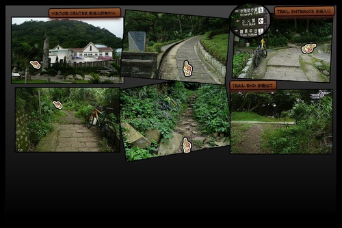
Itinerary 行程: From the Visitor Center follow the Niougangling trail (牛港稜步道), then don't follow the trail signs to the left but go ahead on the paved track. This track leads to the top. Tags: bali, fengshui, guanyinshan, geomancy, grade 4, good maintenance, no carry, graveyard
-
Comments
和平與騎 Take a ride on the wild side


