-
虎頭山 18-20 Hutoushan 18-20

雖然虎頭山公園主要是走路散步的地方,但是這裡有一些很有意思的道路。有的比較平騎, 有的上坡去,也有的下坡去。The Hutou Mt. Park is mainly dedicated to hiking, however there are some very interesting itineraries to ride whatever flat, uphill or downhill.
全路資料 
高差: 140公尺
類型: 循環Global route
Elevation gain: 140m
Type: Loops越野細節 
級: 1到3 - 容易
質量: 很好
攜帶: 不用Off-road details
Grade: 1 to 3 - Easy
Track quality: Excellent
Carry: No因為虎頭山公園包括一個也漂亮也涼爽的森林,所以很多人來那裡玩玩。週末这個公園大概是桃園市最熱鬧的地方!可是因為那麼多人來散步,所以我們應該很小心別的人而且我們不可以騎單車得太快。。。
Hutoushan park is a very popular hiking place above the major city temples. On week-ends it is one of the busiest places of the city and the area around the temples turns into a sort of street festival. I think the park deserves its popularity because the place is home of a marvelous forest bringing a lot of freshness which is especially delectable in summer… But since the park drains a lot of hikers, this is really not a place to freak out on the bikes; nevertheless there are a couple of nice and safe itineraries.


先有兩條道路,我覺得很適合上坡騎自行車的,而且它們比“桃11”公路真好玩。第一條是路線20,因為這條路線都在森林理,所以很涼爽。而且雖然步道不寬但是很平穩,就比較容易上坡騎。先地上是泥土,然後是狹窄的水泥路。第二個是路線18b. 雖然第一段的地上是狹窄的水泥路,但是比路線20難上坡騎車,而且沒有森林。
First there are two routes which are suitable to climbing the hill and provide excellent alternatives to the asphalt road 桃11. The best one in my view is the route #20, which is totally in the forest and really fresh. It is a narrow track with a strong probability to meet hikers, so I don't advise to ride it down. But is is not very steep (maybe 8-10%) and the surface is smooth : dirt in the first part, then a concrete strip after reaching the ridge.
Another option to climb up the hill is the route #18b. The first part of this route has a concrete strip, however it is more challenging to ride than route #20 and outside the forest.
另外,路線19“Park Avenue"很有意思。 它是虎頭山區最長的路線,而同時差不多是最簡單的。從長壽路164巷,除了兩個,三個部分以外,下坡的跟上坡的都好平穩。路線19通常寬,到了铺油公園路铺油,快往左轉,騎過一個大停車場,然後到一條道路下去騎,直到長壽路公路(第1)。從那裡很容易到164巷回去。如果我們覺得太累,就可能停留在一個檳榔店加油!
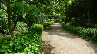
Then a very interesting road is the Park Avenue route #19. This is the longest route in the whole area and also one of the easiest. Starting from the lane 164 of Changshou Rd., it goes smoothly up and down except a couple of short rocky sections. Again be careful since there are many hikers on this wide track, especially on week-ends. After winding along the hills of the park, the route reaches a paved road (GongYuan Lu, 公園路). Then it crosses a parking on the left and reaches another dirt road joining highway #1. It is very easy to loop to the beginning of the route and on the way three betel nut shops can provide you enough energy for another ride ! Unfortunately my camera is out of order and I cannot share the summer outfit of the sexy betel nut girls ; maybe in a later post...

最後,在第18個路線“South Ridge"有比較少人散步,而這條路線是真有意思的中級道路, 又長又同質。地上有許多石頭,可是道路很寬,總是可以選騎石頭,還是騎在旁邊。
Eventually, a little bit aside from the park so less crowded, the route #18 South Ridge is an excellent ride in the moderate difficulty grade. This route is remarkable for its homogeneity and provides a long technical ride full of big unstable stones. But the track is wide, not so steep and is always possible to choose to ride in the stones or on the edge of the track.

Additional information 其他資料:
Access 通路: General access : check our map.
From the top : South Ridge #18 starts from the same esplanade leading to the Belvedere sector #14-17, and used by locals as an airfield for model aircrafts.
From the bottom : On highway #1 (長壽路, Changshou Rd.), before the km 22 there is a small lane 164. At the intersection, a brown sign in chinese indicates Hutoushan. Enter this lane and very soon keep left to strike a plain 12% warmup. The South Ridge #18b follows the same line and the same rhythm on a concrete strip. Else the asphalt road turns left and after another 600m reaches the Park Avenue dirt road #19. Another 400m further there are two pavilions on the right side. Route #20 starts between these two pavilions.
Drinkable water 飲用水: There are no vendors in the park
Itinerary 行程: Watch out that there are a lot of temples, pavilions and hiking tracks in this area, they could not all be drawn on the map.
Difficultes 級: South Ridge grade 3-, Park Avenue grade 1+, route #20 grade 2
 Tags: tags : taoyuan, hutoushan, temple, grade 1, grade 2, grade 3, no stairs, excellent maintenance, no carry
-
Comments
和平與騎 Take a ride on the wild side


